
Whether you are planning a quick weekend getaway or a longer vacation, Arizona is home to some of the most scenic places in the United States. There are several places in Arizona that one can visit specifically for pleasure. It gets even more interesting when you have a drone and would like to capture some of the best scenes from above. Below are some of the best places to fly your drone in Arizona.
1. Cathedral Rock, Sedona
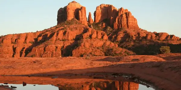
Cathedral Rock, Sedona is one of the most famous landmarks in the U.S. and one of the best places to visit in Arizona. It is located in Yavapai County in the Coconino National Forest. The rock is carved from red sandstone created from sand dunes around the ancient Pedregosa Sea.
The elevation of Cathedral Rock’s summit is 4,921 feet, and reaching that summit is the goal of thousands of hikers every year. Named Cathedral Rock Trail, the steep, short ascent starts at the Back O’ Beyond trailhead and climbs all the way to the gaps or saddle points in Cathedral Rock. The scenic place provides a clear space for you to fly your drone without interference from many members of the public and will help you capture some of the best shots.
2. Antelope Canyon, Monument Valley
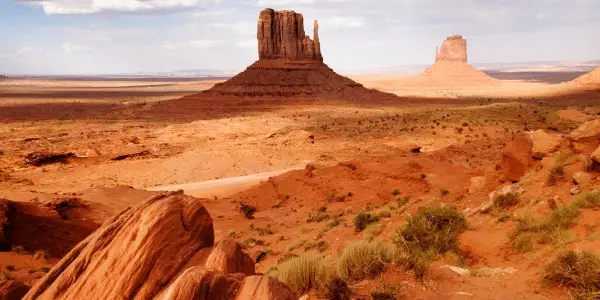
Located on Native American Navajo land east of Page, Arizona, Antelope Canyon is made up of two slot canyons: a slot canyon is a deep and narrow canyon formed by water running through several kinds of rocks including basalt, granite, limestone, and sandstone. The name of the canyon comes from the fact that there used to be many pronghorn antelope living in the canyon. Cattle also used to graze here. The two canyons are called Upper Antelope Canyon, or the Crack; and Antelope Canyon, or the Corkscrew.
3. The Wave
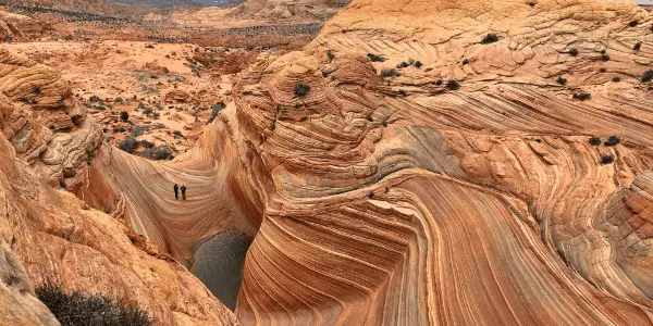
The wave is a sandstone formation with brilliant, undulating, colorful layers resembling waves. It is located close to the border between Arizona and Utah on the steep slopes of the Coyote Buttes and it is one of the top Arizona tourist attractions. The Wave is very popular among drone photographers as well as hikers who love the challenging, rugged, trail-less hike they have to brave in order to reach their destination. The Wave consists of U-shaped troughs formed by erosion of Navajo Sandstone during the Jurassic period.
4. Barringer Crater
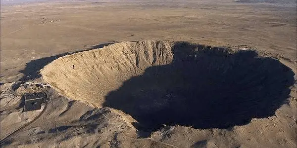
Barringer Crater is a meteor crater near Winslow, Arizona, a popular tourist destination, and the source of endless speculations about the origin of this perfectly round giant hole in the ground. The first person to venture a guess that the hole was created by an impact from a meteor was Daniel Barringer, who gave it the name and whose family also owns the crater and the surrounding land. The big hole is 4,100 feet in diameter and 570 feet deep. It was created about 50,000 years ago by an asteroid about 130 feet wide. Scientists believe that the asteroid was a part of a larger asteroid that broke apart while passing through the atmosphere. Many drone photographers visit these sites every year to capture an aerial view of the crater which gives a surreal feel to tourists.


No drones at the wave either
I visited the Barringer Meteor Crater in April 2022. “No Drone” signs are posted and an employee confirmed that drone flying is no longer permitted at the crater.